[ad_1]

Context:
An exchange of fire between the police forces of both the States on July 26 left six Assam policemen and a civilian dead and 60 others, including Cachar district’s Superintendent of Police injured.
Assam claimed the firing was one-sided and unprovoked while Mizoram said they had retaliated to the aggression by the Assam police.
Now, the Chief Ministers of Assam and Mizoram have sought to ease tension along their troubled inter-State border after a telephonic discussion with Union Home Ministry.
Assam-Mizoram: What is the demarcated boundary?
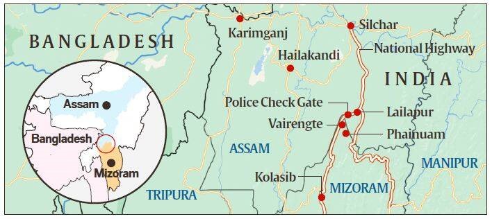
- Mizoram borders Assam’s Barak Valley, and both border Bangladesh.
- The boundary between the two states, which runs 165 km today, has a history dating back to the time when Mizoram was a district of Assam and known as Lushai Hills.
- Boundary demarcations in 1875 and 1933, particularly the second one, are at the heart of the dispute.
- The 1875 demarcation, notified on August 20 that year, derived from the Bengal Eastern Frontier Regulation (BEFR) Act, 1873.
- It differentiated Lushai Hills from the plains of Cachar in Assam’s Barak Valley.
- This was done in consultation with Mizo chiefs, and it became the basis for the Inner Line Reserve Forest demarcation in the Gazette two years later.
- The 1933 demarcation marks a boundary between Lushai Hills and Manipur, beginning at the tri-junction of Lushai Hills, Cachar district and Manipur.
- The Mizos do not accept this demarcation on the ground that their chiefs were not consulted this time.
Situations that led to the two differing notifications:
- British tea plantations surfaced in the Cachar plains during the mid-19th century. It covers the Barak Valley – now comprises the districts of Cachar, Hailakandi and Karimganj.
- Their expansion led to problems with the Mizos whose home was the Lushai Hills.
- In August 1875, the southern boundary of Cachar district was issued in the Assam Gazette.
- The Mizos say this was the fifth time the British had drawn the boundary between the Lushai Hills and the Cachar plains.
- But this was the only time when it was done in consultation with Mizo chiefs.
- This demarcation also became the basis for the Inner Line Reserve Forest demarcation in the Gazette two years later.
- But in 1933, the boundary between Lushai Hills and the then princely state of Manipur was demarcated.
- This notification said the Manipur boundary began from the trijunction of Lushai Hills, Cachar district of Assam and Manipur state.
- The Mizos do not accept this demarcation, and point to the 1875 boundary which was drawn in consultation with their chiefs.
When did the dispute become so bitter?
- The dispute has been simmering since Mizoram became a Union Territory in 1972 and then a state in the 1980s.
- The two states signed an agreement that status quo should be maintained at no-man’s land set up in the boundaries.
- While alleged transgressions have often happened over the decades, skirmishes have happened very frequently in recent months.
- While Assam sees its claimed boundary as transgressed, Mizoram cites unilateral moves by Assam inside Mizoram territory.
- Mizoram claims that both Assam and Mizoram authorities have undertaken construction work at Buarchep village of Mizoram, and that the Home Ministry is aware of all these issues.
- In recent months, several huts and small shops have been torched, and violent clashes have taken place on issues as petty as claims over betel nut cultivation, with plantations belonging to two residents of Mizoram allegedly set ablaze.
- There have been clashes between villagers of Lailapur and Vairengte, and between residents of Karimganj (Assam) and Mamiut (Mizoram).
- There are many issues when people of a state feel that their land and resources are being used by the migrants from other states.
- This happens when there are not enough resources in the state which makes the job seekers move to other places.
- The most long-standing issue is the issue of water resources among the people of India. Due to increased demand for water people migrate and create ruckus.
Border disputes can only be resolved through discussion:
- There is no sure-shot and quick solution possible to the border disputes between various states without a spirit of give and take, and a civic engagement brokered by the Union government.
- After discussions by Home Ministry with both state governments, Mizoram has said it wants “that the inter-state border issue with Assam be resolved in an atmosphere of peace and understanding”.
- It has also called upon Assam to create “congenial environment” for peaceful resolution of the dispute.
- Further, a time-bound court-monitored commission involving local communities in joint demarcation exercises should be announced.
- Assam Chief Minister and Mizoram Chief Minister tagged each other in their tweets while calling for peace. The previous day, they had sparred publicly on Twitter.
Clear dialogue between both sides, aided by the Union government, is needed to resolve the issue. The border demarcation in place must be reinforced to remove any confusion.
Conclusion:
In regard to border disputes, states should be sensitive to and accommodative of each other’s interests so that the entire region can prosper.
The various boundary issues can be settled in case the satellite mapping of actual borders is done in the country. The interstate council must be revived so as to provide better options for dispute settlements.
Also, Zonal Councils can be revived to inquire and advice on disputes in such matters.
The Constitution’s mechanisms for addressing inter-state disputes should be duly used. This includes activating an Inter-State Council (Article 263) or asking the Supreme Court to adjudicate (Article 131).
[ad_2]